
Facilities/Map
The Deseret Peak Complex is a state of the art well maintained facility. We work hard to keep our facilities clean and safe for our patrons. If your visit was less than satisfactory, please let us know.
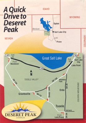
Area Map
The following is an area location map and facility map. If you need further directions or questions feel free to give us a call. We can be reached at (435) 843-4000.
Map and Directions
Area Map
Directions:
From Salt Lake City: Take I-80 West from SLC, take exit 99 to Tooele. Now traveling on SR 36. Continue past Lake Point. Before Stansbury Park turn right at street light SR 138. Proceed to Sheeplane and turn left. The Complex is at the corner of Sheeplane and SR 112 and must be entered from SR 112.
From the South on SR 36: Coming into Tooele on SR 36 traveling North. SR 36 becomes Tooele’s main street, turn left at street light 200 North. Proceed on 200 North out of Tooele and 200 North SR 112. The Complex is at the corner of Sheeplane and SR 112 and must be entered from SR 112.
From Wendover: Take I-80 East from Wendover, take exit 84 to Grantsville. Now traveling on SR 138 through Grantsville City. At the East end of Grantsville City turn right onto SR 112. The Complex is at the corner of Sheeplane and SR 112 and must be entered from SR 112.
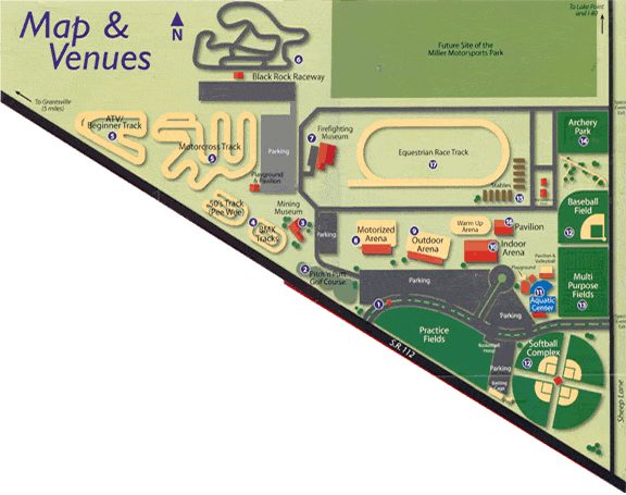
1- Entrance Information Booth
2- Pitch n’ Putt Golf Course
3- Oquirrh Mountain Mining Museum
4- BMX Track
5- Motocroos/ATV/Beginner tracks
7- Utah State Firefighting Museum
8- Motorized Arena
9- Outdoor Arena
10- Indoor Arena
11- Aquatic Center
12- Softball Complex and Baseball Field
13- Multi-Purpose Fields
14- Archery Park
15- Horse Stables
16- Large Pavilion
17- Equestrian Race Track
18- Convention Center